

I am using this page to keep track of which hikes I’ve done in each canton. And just for fun, I’ve picked a favorite hike to highlight for each canton. There are 26 cantons in Switzerland and I want to have a blog post for at least one hike in every canton. So, how close am I to reaching that goal? So far, I have done significant hikes in 24 of 26 cantons.
The sections below have my favorite hike for each canton along with a link to all hikes I’ve done in that canton:
Note: The links to all hikes I’ve done in each canton will show all hikes that had any part of the hike that went through that canton, even if only briefly. When choosing a favorite for the canton, I tried to prioritize hikes where the vast majority, if not all, of the hike was in that canton.
Aargau (AG)
For my favorite hike in Aargau, I’ve chosen:
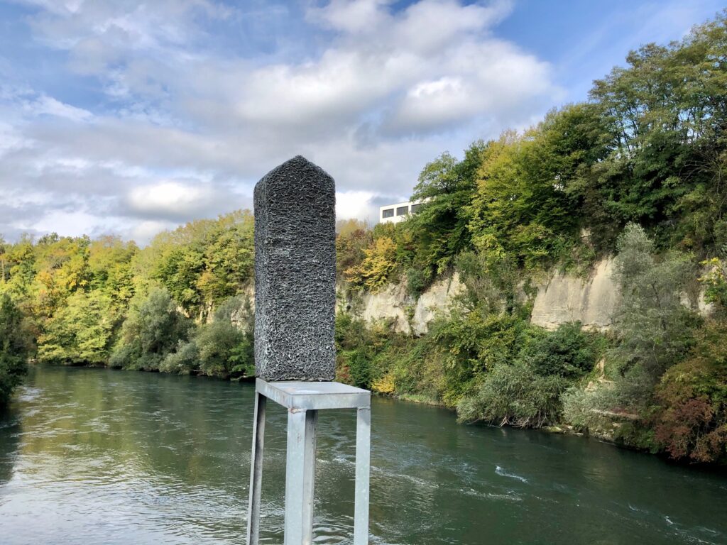
The Limmat Culture Trail
The Limmat Culture Trail (length 9 km, ascent 100 m, descent 100 m) is a loop trail along the Limmat river between Wettingen and Baden. Along the trail are 27 contemporary art installations by Swiss artists. This trail is perfect if you can’t decide between hiking and going to a museum.
For all hikes I’ve done in this canton see, Hikes in Canton Aargau(AG).
Appenzell Ausserrhoden (AR)
For my favorite hike in Appenzell Ausserrhoden, I’ve chosen:

The Alpine Panorama Trail – Stage 2 Trogen to Appenzell
Stage 2 of the Alpine Panorama Trail (Route 3) is a 13 km trail with 560 m ascent and 700 m descent that goes from Trogen to Appenzell, spending about two-thirds of the time in Appenzell Ausserrhoden. This trail is where the Alpine Panorama trail starts to live up to its name.
For all hikes I’ve done in this canton see, Hikes in Canton Appenzell Ausserrhoden (AR).
Appenzell Innerrhoden (AI)
For my favorite hike in Appenzell Innerrhoden, I’ve chosen:

The Alpine Panorama Trail – Stage 3 Appenzell to Schwägalp
Stage 3 of the Alpine Panorama Trail (Route 3) is a 16 km trail with 1150 m ascent and 580 m descent that goes from Appenzell to Schwägalp.
For all hikes I’ve done in this canton see, Hikes in Canton Appenzell Innerrhoden (AI).
Basel-Landschaft (BL)
For my favorite hike in Basel-Landshaft I’ve chosen:

The Baselbieter Chirsiweg (Cherry Way) – Oltingen to Sommerau
The Baselbieter Chirsiweg (Cherry Way) is an 11 km trail with 400 m ascent and 260 m decent that officially goes from the Sommerau train station to the Oltingen, Post bus stop. We hiked it in the opposite direction (Oltingen to Sommerau) and had a very lovely time even though the cherry trees that give this trail its name weren’t fully in bloom yet. Also along the way are an interesting cave to peek into and a charming waterfall to admire.
For all hikes I’ve done in this canton see, Hikes in Canton Basel-Landschaft (BL).
Basel-Stadt (BS)
For my favorite hike in Basel-Stadt, I’ve chosen:

The Dreiland Wanderweg – Stage 1 Basel, Schifflände to Riehen, Hörnli Grenze
Stage 1 of the Dreiland Wanderweg or Three Country Trail (Trail 67) is 16 km with 200 m ascent and 190 m descent and goes from the Schifflände boat port in Basel to the Riehen, Hörnli Grenze bus stop on the border with Germany. This hike is a lovely tour of the city.
For all hikes I’ve done in this canton see, Hikes in Canton Basel-Stadt (BS).
Bern/Berne (BE)
Bern is a large canton with a lot of variation and it was rather difficult to choose, but in the end I went with a very famous hike. For my favorite hike in Bern/Berne, I have chosen:

Grindelwald First to Bachalpsee
We did this trail as part of a two-day itinerary in the Jungfrau region. We didn’t have the best weather but it was still so beautiful I dream of going back.
For all hikes I’ve done in this canton see, Hikes in Canton Bern/Berne (BE).
Fribourg (FR)
While my original choice for favorite Fribourg hike, The Trans Swiss Trail – Stage 7 Neuchâtel to Murten, deserves a mention, I have a new favorite hike for this canton. For my favorite hike in Fribourg, I’ve chosen:

The Alpine Panorama Trail – Stage 20 Schwarzsee to Jaun
Stage 20 of the Alpine Panorama Trail (Route 3) is a 12 km hike with 720 m ascent and 750 m descent that goes from Schwarzsee to Jaun. The views on this stage are truly incredible! The Schwarzee lake, the Breccaschlund high mountain valley, and the top of the Euschel Pass – each unique and breathtaking!
For all hikes I’ve done in this canton see, Hikes in Canton Fribourg (FR).
Genève (GE)
I haven’t blogged any hikes in this canton.
Glarus (GL)
Glarus has some really spectacular hikes, but there is one that really stands out for me. For my favorite hike in Glarus, I’ve chosen:

The Chüebodensee loop hike with a detour up to the Wildmadfurggeli at Elm
The Chüebodensee loop hike with a detour up to the Wildmadfurggeli at Elm (10 km hike with 857 m of ascent and decent) is one of my all time favorite hikes. Part of the charm of this hike is that you can end the day with a super fun mountain cart ride.
For all hikes I’ve done in this canton see, Hikes in Canton Glarus (GL).
Graubünden/Grisons(GR)
I only did two hikes plus one snowshoe walk in this canton and I really loved all three. I should really do more hiking in this canton! However, since I had to choose one for my favorite hike in Graubünden/Grisons, I’ve chosen:

The Senda Ruinaulta Trail from Laax, Staderas The Senda Ruinaulta is a 10 km, 360 ascent/descent loop trail easily accessed from the Laax, Staderas bus stop. Fantastic views of Lake Cauma and of the Rhine gorge (sometimes called the Swiss Grand Canyon).
For all hikes I’ve done in this canton see, Hikes in Canton Graubünden/Grisons(GR).
Jura (JU)
For my favorite hike in Jura, I’ve chosen:
The Trans Swiss Trail – Stage 2 St-Ursanne to Soubey
Stage 2 of the Trans Swiss Trail is 17 km, long with 260 m ascent and 220 m descent. This stage starts in the lovely medieval town of St-Ursanne and follows along the Doubs river going up-stream to the tiny village of Soubey. This is a very peaceful, relaxing, and pretty hike. It is also the hike where we really fell in love with Tête de Moine cheese.
For all hikes I’ve done in this canton see, Hikes in Canton Jura (JU).
Luzern (LU)
Choosing a favorite hike for Luzern was a bit difficult as most of the hikes I’ve done did not take place entirely in Luzern and often the best parts were in another canton (The Mark Twain Trail – Weggis to Rigi Kulm or The Trans Swiss Trail – Stage 16 Sörenberg to Giswil). However, there was one hike we did that was entirely in canton Luzern. For that reason, for my favorite hike in Luzern I’ve chosen:

The Alpine Panorama Trail – Stage 11 Luzern to Malters
Stage 11 of the Alpine Panorama Trail (Route 3) is a 13 km long trail with 490 m ascent and 430 m descent. This stage starts with a lovely stroll past the Kapellbrücke (Chapel Bridge) and through the cobblestone streets in the old town of Luzern.
For all hikes I’ve done in this canton see, Hikes in Canton Luzern (LU).
Neuchâtel (NE)
For my favorite hike in Neuchâtel, I’ve chosen:

The Creux du Van Loop Trail
The Creux du Van Loop Trail is a 14 km hike with approximately 780 m of ascent and decent. This moderately challenging trail leads up to the Creux du Van, a large semi-circular rock cliff. The Creux du Van is a completely natural formation shaped solely by ice, erosion, and rain, and an impressive sight.
For all hikes I’ve done in this canton see, Hikes in Canton Neuchâtel (NE).
Nidwalden (NW)
For my favorite hike in Nidwalden, I’ve chosen:
The Trans Swiss Trail – Stage 19 Stans to Seelisberg
Stage 19 of the Trans Swiss trail is 20 km long with 820 m ascent and 480 m descent and goes from Stans to Seelisberg. This stage includes wonderful lakeshore views as well as a steep ascent through the Risleten Gorge past a really impressive waterfall.
For all hikes I’ve done in this canton see, Hikes in Canton Nidwalden (NW).
Obwalden (OW)
Shortly after we moved to Switzerland, our first Swiss mountain experience was the magical 8 kilometer long sled run at Melchsee-Frutt. Since then, we have returned several times to Melchsee-Frutt to sled and to do winter and summer hikes. So, although we have done a number of other amazing hikes in Obwalden, it felt right to choose one of the Melchsee-Frutt hikes as my favorite hike in Obwalden and so I’ve chosen:

The Erzegg Roundtour at Melchsee-Frutt
A hike (11 k) with everything I think a Swiss mountain hike should have – dramatic mountain peaks, alpine lakes, rolling meadows with grazing sheep and cows, and the sound of clinking cow bells!
For all hikes I’ve done in this canton see, Hikes in Canton Obwalden (OW).
St. Gallen (SG)
We’ve done a lot of great hikes in St. Gallen, but choosing a favorite was easy as one of them is also my very favorite hike in all of Switzerland. For my favorite hike in St. Gallen, I’ve chosen:


Pizol to Weisstannen via the Batöni Waterfall Arena
The trail from Pizolhütte to Weisstannen, Oberdorf is 12 km long with 368 m of ascent and 1594 m of descent. This trail passes the impossibly beautiful Wildsee glacial lake as well as the Batöni Waterfall Arena. Both of which are so incredible I had to use two photos as the highlight for this hike. We also added a short scramble up to the Hochwart peak (the peak just behind my head in the first photo). The views from the peak are also amazing!
That said, this is one of the most difficult hikes we’ve done. The post linked above provides some information on alternative ways to see the best views.
For all hikes I’ve done in this canton see, Hikes in Canton St. Gallen (SG).
Schaffhausen (SH)
Although the loop trail for the Rhine Falls, one of the most visited tourist sites in Switzerland, straddles the border of Schaffhausen and Zürich, I decided to choose a hike that features a bit of Swiss trivia. For my favorite hike in Schaffhausen, I’ve chosen:

The Nordspitz Panorama Trail from Bargen
The Nordspitze Panoramweg trail (14 km, 520 ascent/descent) is a loop trail starting in Bargen that takes you past the most northern point in Switzerland.
For all hikes I’ve done in this canton see, Hikes in Canton Schaffhausen (SH).
Schwyz (SZ)
Schwyz is another canton with a lot of great hikes (including the hike to the top of the Grosser Mythen Peak where I took the cover photo for this post.) With so many to choose from, I decided, for this canton, to follow the crowd and choose one of Switzerland’s most popular hikes. For my favorite hike in Schwyz, I’ve chosen:

The Stoos Gratweg Trail from Klingenstock to Fronalpstock. This trail is a short (4 km), not too difficult (380 m ascent, 400 m descent), panorama ridge hike. Not far from Zürich, this hike is popular for a reason – the views are mind-bogglingly stunning! But, be aware there are many sections with steep drop-offs, often on both sides of the trail. If you are afraid of heights, this is not the trail for you.
For all hikes I’ve done in this canton see, Hikes in Canton Schwyz (SZ).
Solothurn (SO)
For my favorite hike in Solothurn, I’ve chosen:
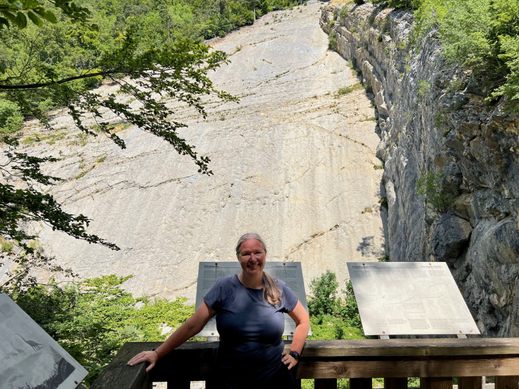
The Waldrandweg – Oberdorf, SO to Grenchen
The Waldrandweg is a 12 km hike with 200 m ascent and 420 descent that goes from Oberdorf SO to Grenchen. Along the way, this trail passes an old quarry where a large number of dinosaur tracks can be seen.
For all hikes I’ve done in this canton see, Hikes in Canton Solothurn (SO).
Thurgau (TG)
For my favorite hike in Thurgau, I’ve chosen:
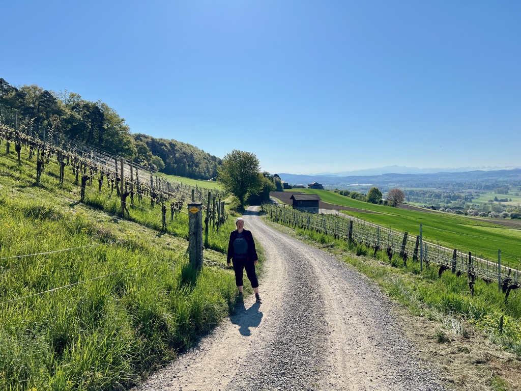
The Thurgauer Rebenweg Trail
The Thurgauer Rebenweg Trail is 14 k long with 240 m ascent and 300 m descent and goes from Oberneunforn to Frauenfeld. As I expected from the trail name, “Rebenweg” meaning vine path, this trail passes through vineyards, but I was also pleasantly surprised that, on a clear day like we had, this trail also has beautiful views of the distant alps. Along the way we stopped at the Karthaus Ittingen, a former monastery, and now art and history museum, which was fascinating and well worth our time.
For all hikes I’ve done in this canton see, Hikes in Canton Thurgau (TG).
Ticino (TI)
For my favorite hike in Ticino, I’ve chosen:
The Trans Swiss Trail – Stage 31 Lugano (Paradiso) to Morcote This hike is 12 km long with 840 m ascent and 880 m descent. This was one of prettiest hikes of the entire Trans Swiss Trail with some absolutely stunning views from the top of Monte San Salvatore. Plus, Morcote is an absolutely adorable village to end the hike in. Note: If you would prefer to skip the steep part of the hike, there is a funicular you can take up to the top.
For all hikes I’ve done in this canton see, Hikes in Canton Ticino (TI).
Uri (UR)
For my favorite hike in Uri, I’ve chosen:
The Trans Swiss Trail – Stage 22 Wassen to Andermatt This hike is 10 km long with 680 m ascent and 150 m descent. Along the way it passes through the Schöllenenschlucht gorge and over the dramatic Teufelsbrücke (Devil’s Bridge).
For all hikes I’ve done in this canton see, Hikes in Canton Uri (UR).
Valais/Wallis (VS)
I only blogged one hike in canton Valais, so the choice was easy. For my favorite hike in Valais/Wallis, I’ve chosen:

The Gemmipass – Leukerbad (Gemmibahn) to Kandersteg (Sunnbüel) The Gemmipass is a historic mountain passage connecting Canton Valais and Canton Bern, which has been used since ancient times (coins from the Roman empire have been found here). The hike is about 8.5 km with about 80 m of ascent and 480 m of decent along well maintained gravel paths. Although only half of this hike is in Valais, it is a spectacular half and justifies it as my choice.
For all hikes I’ve done in this canton see, Hikes in Canton Valais/Wallis (VS).
Vaud (VD)
Although I have done hikes in this region, they were before I started blogging. The one hike that passed through Vaud that I have blogged only passes through Vaud for such a brief time that I can’t pick it as a favorite.
For all hikes I’ve done in this canton see, Hikes in Canton Vaud (VD).
Zug (ZG)
For my favorite hike in Zug, I’ve chosen:

The ZBB Trail Suggestion #12 from Zugerberg to Baar This trail is one of the long trail suggestions found on the Zugerberg Bahn (ZBB) website. This 13 km trail has about 208m ascent and 550 m descent. It starts at Zugerberg, Bergstation and ends at the Baar train station. Along the way are great views of Zug, castle ruins, a small waterfall, and a cave you can tour.
For all hikes I’ve done in this canton see, Hikes in Canton Zug (ZG).
Zürich (ZH)
For my favorite hike in Zürich, I’ve chosen:

The Zürichsee-Rundweg Trail
This is a 10 stage trail that starts in Bürkliplatz and loops around lake Zürich (including the Obersee). While only 8 of the 10 stages are in canton Zürich, I’ve still chosen this hike as my favorite because it is the trail that kick-started my love of multi-stage trail hiking and got me started with the blog.
For all hikes I’ve done in this canton see, Hikes in Canton Zürich (ZH).
Page Edit History:
2026 January 2 – First release
2026 February 16 – Added link to snowshoe walk in Graubunden
2026 April 6 – Added a favorite hike for Basel-Landshaft
2026 April 27 – Added a favorite hike for Thurgau
2026 May 25 – Changed my favorite Friborg hike from The Trans Swiss Trail – Stage 7 Neuchâtel to Murten to The Alpine Panorama Trail – Stage 20 Schwarzsee to Jaun
2026 June 15 – Added a favorite hike for Solothurn
Leave a Reply