
The Chüebodensee loop hike at Elm is a 8 km hike with approximately 640 m of ascent and decent. This moderately challenging trail leads up to the Chüebodensee, a small alpine lake. Last year, I tried to hike this trail, but it was too challenging for me and I had to give up before reaching the lake. After hiking a lot over the past year, and getting in better shape, I decided to give it another try. I’m so glad I did. Not only did I redeem myself by making it to the top, I thoroughly enjoyed myself as this is a fantastic hike with amazing views. So worth the effort!
Note: I hiked this trail again in September 2024, but also did the detour up to the Wildmadfurggeli. It adds 2 km and another 200 m or so of ascent/descent but it is 100 percent worth it!
Detail Summary
| Location: | Elm Sportbahn Canton Glarus |
| Car: | Zurich – > Elm Sportbahn, Obmoos, 8767, Switzerland – 1 hr 20 min |
| Train/Bus: | Zurich HB -> Elm Sportbahn – 1 hr 50 min |
| Cost 2021: | Gondola Elm -> Ämpächli + Mountain Cart Adult/24 CHF, Child/16 CHF |
| Safety Notes: | For the mountain carts, children need to be 12 years old and at least 140 cm tall. Scooters are also available and can be ridden alone by children age 9 and up. Younger children can share a scooter with a parent. Helmets are included with the scooter and mountain car rental. |
Additional Info
Getting To Elm and to the Trail
The Elm Sportbahnen gondola is easily reached by public transportation or by car. By public transport, there is a bus stop (Elm Sportbahn, Obmoos) directly at the gondola. When driving, there is a parking lot across the street from the gondola. A second overflow parking area is located about 500 meters further down the road. We were certain we wanted to end our day riding the mountain cart down, so we purchased a combo ticket for a gondola ride up to Ämpächli and single cart ride down.


After getting off the gondola at Ämpächli, we walked past the restaurant, playground and trampolines and across the field. The Chüebodensee loop trail starts by following the Reisenwald trail, a theme trail for children with a story about a Giant. The Reisenwald trail is a loop and at the far end of the loop is a playground, picnic tables and toilet and it is where you leave the Reisenwald trail to continue on the Chüebodensee trail.
Hiking Up the Chüebodensee Trail
The Chüebodensee trail is a red and white mountain trail that begins in an alpine cow pasture traveling along a small stream. After crossing the stream on a small plank bridge, it begins the steep ascent up to the lake. As we did this trail last year, I didn’t take a lot of pictures on the way up until we passed the point where we turned around. (If you want to see more pictures of this part of the trail, see the post Hiking at Elm + Mountain Carts.) To give you an idea of how steep the trail is, I put a square around my kids on the trail above me in the second picture. We definitely needed our hiking sticks on this trail.


When we reached the small plateau with large rocks where we turned around last year, we took a break to take some pictures and to have some water. Feeling good, we pressed on up the trail. As we got higher up, there was still some snow on the trail (late June).


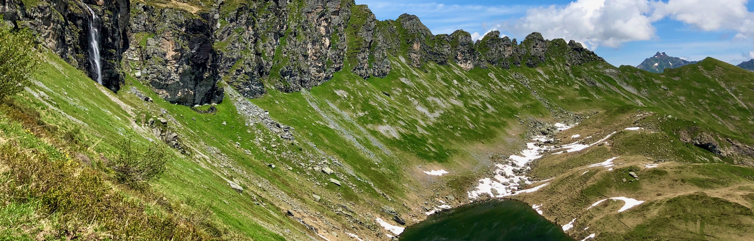
When we finally crested the ridge and came to the Chüebodensee, it was lunch time. There were a lot of rocks here to sit on to enjoy the view while we ate our sandwiches. So beautiful!


The lake is not quite the high-point of the trail. So after eating lunch, we had one more ridge to crest before heading back down.


Detour to the Wildmadfurggeli
I hiked this trail again in September 2024, but also did the detour up to the Wildmadfurggeli. At the point just above the Chüebodensee lake where the trail splits, instead of heading back down, take the trail continuing upwards towards the Wildmadfurggeli. This is a red and white mountain trail with some steep drop offs and rock scrambles but not overly challenging. It adds 2 km and another 200 m or so of ascent/descent, but if you have the time and energy, I highly recommend it.


It is a there and back detour so, when you are done you just rejoin the loop where you left off.
Hiking Down the Chüebodensee Trail
After cresting the ridge, it was time to hike down. The hike down was much easier than the hike up! Not quite as steep as the trail coming up. You can see a good part of the trail down from the top.


When the trail widened out to almost a road, we were down below the tree line. We were surprised here by a wild deer bounding across the path. I didn’t get a picture because it ran off too quickly.


When we reached the restaurant and the gondola station, we were at the end of the hike.


And, of course, like last time, we finished this hike with a mountain cart ride – so much fun!

I’m so happy we went back and tried this hike again. We had a fantastic time!
Leave a Reply