
The Rosinli Rundweg is an easy loop hike in Canton Zürich starting in the village of Kempten. The loop features a view of lake Pfäffiker from the high point of the hike at Rosinli, as well as a nice forest walk along the Chämtner brook past a pretty waterfall. I wouldn’t go out of my way to do this hike, but if you happen to be nearby, it makes for a pleasant afternoon.
Detail Summary
| Where: | Kempten Canton Zürich, Switzerland |
| Train/Bus: | Zürich HB -> Kempten – 38 mins |
| Car: | Zürich -> Kempten- 27 mins |
| What: | Rosinli-Rundeg (SwitzerlandMobility) Trail Map (SwitzerlandMobility) Yellow trail markers Clockwise: Industriepfad -> Rosinli -> Adetswil -> Kempten Counter- clockwise: Industriepfad -> Adetswil -> Rosinli -> Hofhalden -> Wabit ->Kempten |
| Skill: | Easy – About 2.5 hrs Length 10 km, Ascent 320 m, Descent 320 m |
Getting There
This is a loop hike that starts and ends at the Kempten train station making it a very easy hike to do by public transportation. If you plan to drive, as we did, there is parking available at the train station.


After arriving at the train station, we walked past the Migrolino, found our yellow trail marker, and were on our way. There isn’t a specific marker for this trail, but the beginning of this trail is combined with Stage 2 of the Industriepfad which is clearly marked.
The Trail – Up to Rosinli
When we came to a stream, following the Industriepfad signs, we took a left. Then less than a kilometer later, when we came to a marker for Rosinli, we took another left and headed up the hill. After the trail leaves Kempten behind, it passes through a wooded ravine and some fields as it winds its way up to the viewpoint at Rosinli.


Just before getting to the viewpoint, we passed by Hof Warberg, part of the St. Micheal Insitute (german), a farming community offering social therapy for the disabled. Shortly after passing Hof Warberg, we reached the Rosinli viewpoint. There is a restaurant here, but it is currently closed. The view here of lake Pfäffiker is lovely. You are supposed to also be able to see Lake Zürich and Lake Greifen, but only barely, so I considered that description a bit of an oversell. Still, we enjoyed the view.


The Rosinli viewpoint is basically the half-way point of the hike.
The Trail – Back to Kempten
Several paths meet at the Rosinli restaurant, so it can be a bit tricky to get the right one. (We took the wrong path at first by staying on the paved trail.) The path we wanted was behind the restaurant. There are two trails there, and the one marked Adetswil is the one we wanted. After finding the right trail, we soon came to a picnic area, and took a break to eat our sandwiches and enjoy the view before continuing down the path to Adetswil.


At Adetswil, we began to follow the signs towards Kempten. After the trail passed through Adetswil, it entered the forest and headed down into Chämtner ravine. Here the trail again joins the Industriepfad (Industry Path) and you can see how that path got its name. All along this ravine are signs of old industry, including the tower in the second picture, which was part of a water turbine system used to power local factories (german).


As we continued down the path, we passed through a slightly swampy area with, as you can see, a shocking amount of frog eggs. I don’t think I’ve ever seen so many frog eggs all together before.


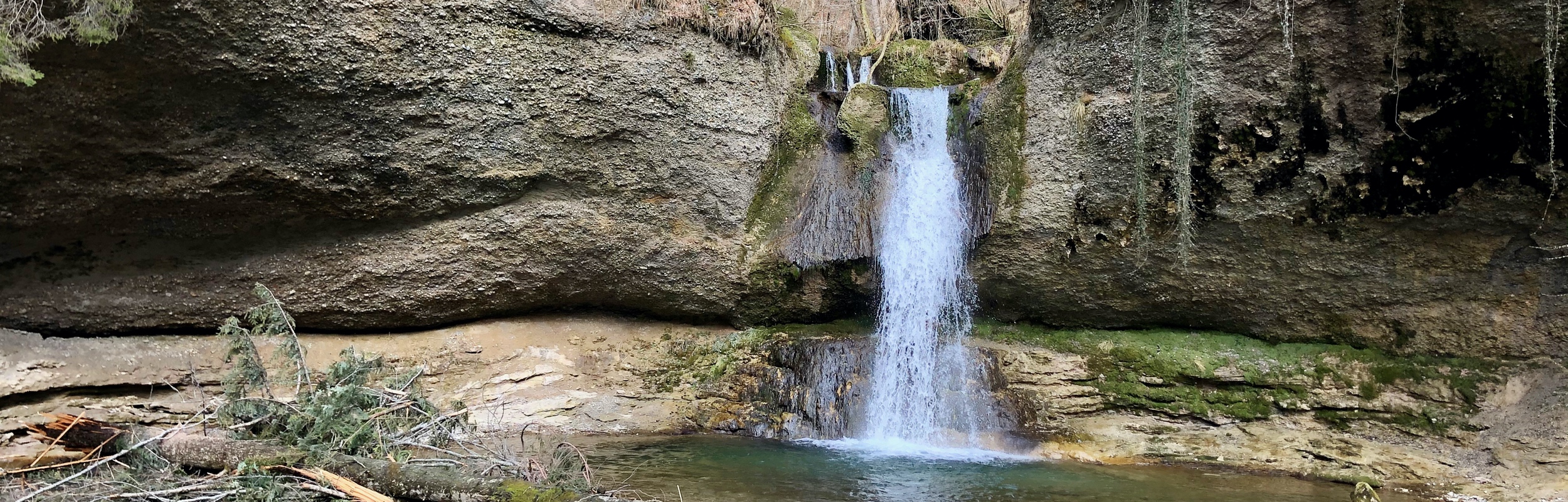
Further down the path, we came to the Grossen Giessen water fall, a real highlight of the hike.

As we continued down the ravine back towards Kempten, we came across a small group of delightful wooden carvings, two of which are below.


After leaving the ravine, the path continues through Kempten. Soon we were retracing our steps from the beginning of the hike, and back at the Kempten train station.


While not a hike I am likely to do again or one that I would really recommend, it was still a nice day out.
Leave a Reply