
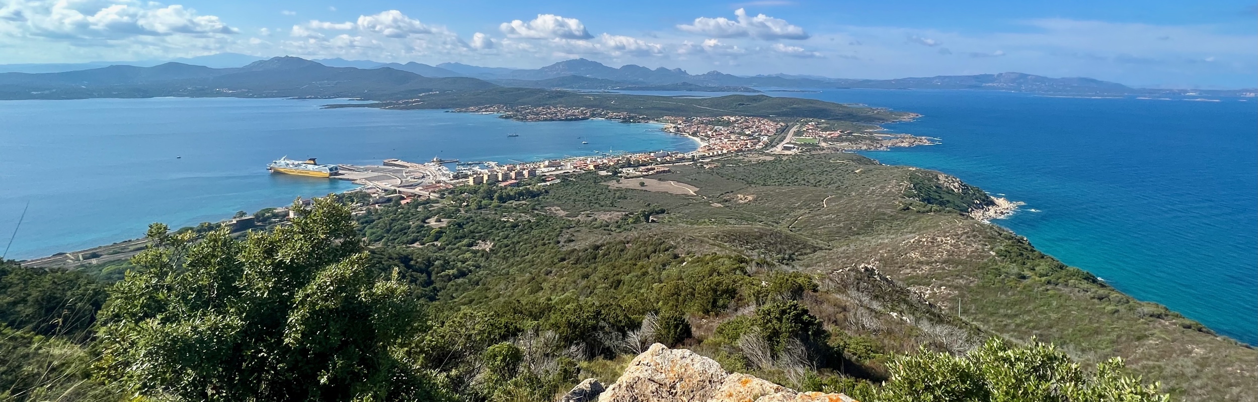
On a recent trip to Sardinia, Italy, we spent a very lovely afternoon hiking in Capo Figari Nature Park by Golfo Aranci. On our hike, we had stunning views of the Gulf of Aranci and the island of Figarolo. We did a loop comprised of the Carbonai, Mount Ruju, and Su Canale trails, and the road Via Cala Moresca. The trails were not well marked (the website says there are information boards but we never saw any), but once we found our way, it was fairly easy walking and a perfect afternoon. My only regret is that we had not packed our swimsuits. The beach at Cala Marasca looked like an amazing place to swim.
Detail Summary
| Where: | Capo Figari Nature Park by Golfo Aranci, Sardinia, Italy |
| Car: | Parking is available by the Golfo Aranci Ferry Port and it is easy to begin the hike from there. There is also a parking lot for the beach near Cala Marasca that would also work. |
| What: | Via G. Marconi/Via Cala Marasca (Paved road in Golfo Aranci near trail head) -> Carbonai Trail -> Mount Ruju Trail -> Mount Ruju Viewpoint -> Mount Ruju Trail -> Su Canale Trail -> Via Cala Moresca (Dirt/Paved road returning to Golfo Aranci) Trail marker descriptions There are few wooden arrow trail markers with the printed trail names, but the trails were not well marked. We used a combination of Google Maps and the map on Komoot, to navigate our way. We did not end up doing the route we had planned, but it was still very nice. |
| Skill: | Easy – About 2 hrs 45 min Length 9 km, Ascent/Descent 281 m |
| Cost | Free |
Additional Info
Getting There
For our Sardinia trip, we rented a car. To get to this hike, we drove to the town of Golfo Aranci, roughly a half-hour drive from Olbia. We parked the car near the ferry port in Golfo Aranci and after a short walk though town, we turned up Via de Martenai. After going under an underpass, we turned right on Via G. Marconi/Via Cala Marasca (following the sign pointing to Cala Marasca). Then just a few meters down the road, we arrived at the trail head, a dirt path heading into the scrub.


I may have missed it, but I did not see a trail marker, however this first trail is the Carbonai.
The Trail – Carbonai
The Carbonai was an easy trail to hike with a wide dirt path. While it was not well marked, simply staying on the widest path kept us on track. There are some smaller, paths that seem to lead away from it but perhaps they were only dry water run-off beds and not trails.


There were few steep parts to this trail, but the climb was worth the marvelous views.

When we reached the confluence of the three trails, the Carbonai trail ends and we had a decision to make. We could go right and take the Mt. Ruju trail, or go left and take the Su Canale trail.


We weren’t sure what to do. We had intended to follow the trail marked out by the map on Komoot, however, the trail it follows is not one of the three marked here. (The trail we were looking for is the Arcobaleno.)
The Trail – Mt Ruju
We decided to follow the Mt. Ruju trail, thinking it led to the trail we wanted. It didn’t. It only goes to the view point on the top of Mt. Ruju. By the time we realized this, we were almost to the view point, so we simply continued up to the viewpoint. It was a bit of scramble through some brush at the end, but worth it.


After we reached the viewpoint on Mt Ruju, we simply turned around and retraced our steps back to where the three trails converged and this time we followed the marker towards the Su Canale trail.
The Trail – Su Canale
The Su Canale trail leads down through the valley. Just before it begins the descent, we saw an unmarked trail heading up towards the radio station. This trail is the Arcobaleno trail, the one recommended by the loop on Komoot. The Arcobaleno trail leads to the radio station and to the Semaforo trail. While the views from the Semaforo trail sound wonderful, we had a ferry to catch and we did not want to risk getting lost on the Arcobaleno trail. It looked like quite the scramble through brush and not well marked. In addition, the web site advises only doing this trail with a guide. (The website also said that the Su Canale trail was suitable by bike, and I would call that a bit of a stretch. The trail was very washed out in places and would not be an easy ride at all.) We took the Su Canale trail and enjoyed the lovely valley views as we made our descent.


The Su Canale trail and the Semeforo trails end at the same spot, the stunning Moresca bay, with a gorgeous view of island of Figarolo. Note: Shortly before reaching the bay, the Su Canale trail forked. We went to the right which took us past an old building and then we were stuck behind a fence that we needed to crawl through to continue. We probably should have gone to the left. Oh well. We got to Cala Moresca, anyway. Cala Moresca is absolutely beautiful! The beach looked like the perfect place to take a swim, but sadly, we had not packed our swim clothes.


From Cala Moresca, the trail heads on a road (Via Cala Moresca) along the shore back to Golfo Aranci.
Getting Back
The walk back to Golfo Aranci was a mix of gorgeous views, railroad tracks, industrial roadway, and the Cala Moresca parking lot. Along the way, we were surprised by a turtle crossing our path. After passing the entrance to the Carbonai path where we started the hike, we simply retraced out steps back to the ferry port and our car.


This was a really beautiful hike and I am really glad we did it. What an enjoyable way to spend a warm, clear October day in northern Sardinia.
Leave a Reply