
While taking a trip back to the US to visit family and friends, we went out for a short loop hike at Mount Tom State Reservation in Holyoke, Massachusetts. The trail we did was the Goat Peak View loop trail, a lovely forest hike up to an observation tower with 360 degree views. The trail description listed it as a 5.2 km round trip hike, but my watch said it was much less, at only 3 km. The description didn’t list elevation change, but my watch said it was 120 m ascent and descent, so nothing very steep.
Detail Summary
| Where: | Goat Peak View Loop Trail Mount Tom State Reservation, Holyoke, Massachusetts |
| Car: | Trailhead: Mount Tom Visitor Center (stone house) at the intersection of Reservation Road and Christopher Clark Road |
| What: | Goat Peak View Loop Trail Trail Signalization Trail Head: Mount Tom Visitor Center (stone house) at the intersection of Reservation Road and Christopher Clark Road – Facing the Visitor Center, head to right (west) and past the gate onto Old Reservation Road. This is NOT the road with the signs to Goat Peak at the end of the parking lot. Rather it is a smaller road next to the parking lot that goes briefly downhill. If you don’t spot the next trail marker in about 3 minutes you’ve gone the wrong way. – Turn right on to the Dynamite Trail (yellow blazes) – At the intersection with the John McCool Trail (blue blazes), turn left on to the John McCool trail – At the first trail intersection, take a right on to the short unmarked trail up to the paved road and then take a right onto the paved road. – Follow the brown signs for Goat Peak – At Goat Peak, take the short detour up to the tower to admire the views – Facing the information sign just below the detour up to the tower, turn right and go up a nice area with couple a benches and a pretty view. From there turn Left to join the New England Trail (NET) (white blazes) – Stay on the New England Trail (NET) (white blazes) until you reach a paved road. – Eat the paved road, turn right and walk on the paved road back to Mount Tom Visitor Center. |
| Skill: | Easy – About 1 hr Length 3 km, Ascent 120 m, Descent 120 m |
| Cost 2022 | Daily parking fees May 14 – October 10 MA residents – $5 Non-MA residents – $20 |
Additional Info
| Mount Tom State Reservation (Official Park Info) Trail Description Trial Map |
The Trail
Our trail was part of the Mount Tom State Reservation in Holyoke, Massachusetts. The trail head was located at the Mount Tom Visitor Center at the intersection of Reservation Road and Christopher Clark Road. There is no public transportation to this trail, so we drove and parked in the lot next to the trail head. There are park fees from May to October but, as it was still April, there were no fees, but the visitor’s center and other services were closed. After parking, we looked for our trail head. Initially, we took the road with the sign saying “Goat Peak” but this wasn’t the trail we wanted, so we turned around and started again. To find the trail we wanted, facing the Visitor Center, we headed to the right and past the gate onto Old Reservation Road. This is the smaller road next to the parking lot that goes briefly downhill. After about 3 minutes, we found the trail marker we were looking for, the brown sign for the Dynamite Trail, where we took a right and we began following the yellow blazes through the forest trail.


After following the yellow blazes for a little more then half a kilometer, we came to the brown sign indicating the intersection with the John McCool trail. Here, we turned left onto the John McCool trail and began following the blue blazes.


At the next trail intersection, we took the short unmarked trail up to the paved road. Here, we took a left onto the road and continued on our way.


When we came to a field alongside the road with a brown sign for Goat Peak, we took a right through the field and to the paved road where the was another sign for Goat Peak. We then stayed on the road until we reached the intersection with an information sign about Goat Peak.


At the information sign, we decided to take a right and take a break on the benches there where we also enjoyed the lovely view. We then turned around and hiked up the last bit to the observation tower.


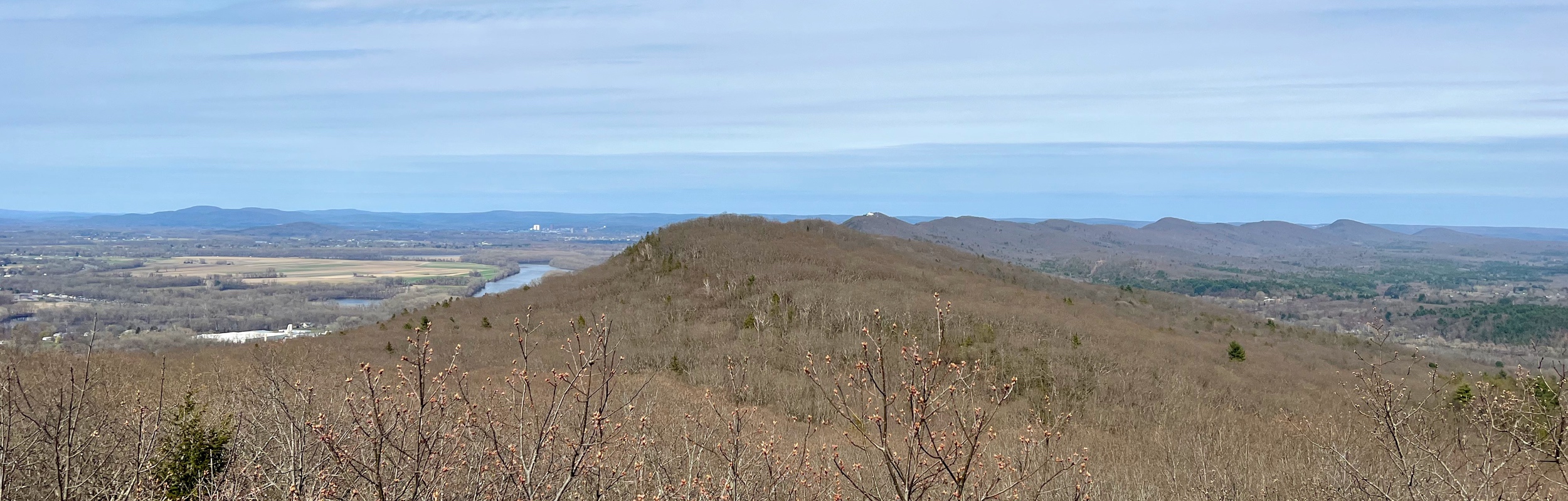
After climbing the tower, we had a fantastic 360 degree view. It was definitely worth climbing to the top!


While the views from Goat Peak were very pretty, we were disappointed to see there are no actual goats here. After leaving the tower, we went back down to the information sign. To finish the hike, we wanted to take the New England Trail (NET) (white blazes) back. We had a little trouble finding the trail at first. Facing the information sign, we took the trail straight ahead, but we weren’t seeing any white blazes. We then saw a cutoff to another trail to the right leading to a trail with white blazes and we were then on our way. I think that when we were facing the information sign, we should taken the trail to the right back to the area with the benches we were at earlier and we could have followed the white blazes from there. No matter, we were on the right trail and on our way.


At one point, our trail crossed over the Dynamite Trail (yellow blazes), but we were sure to stay to the right and continue following the white blazes. When we reached the paved road, we took a right and followed the road back to the visitor center. This is the main road, so there was some traffic to be aware of.


This was enjoyable hike and a really nice leg-stretch after spending so much time in the car traveling around.
Leave a Reply